Follow the steps below to set up your new Marine System.
Note: This walkthrough is based on the Firmware v.76E and the SSM App v.5.0.129 (Available in the Google Play Store).
TRAINING: It is often preferred to train ahead of time and avoid mobilizing on a boat to minimize cost and complexity. You can connect all devices without the streamer and simulate a marine survey on land using a cart and pushing the system. Or you can load the system in a vehicle and drive slowly in a parking lot or road where 2-3 mph or 3-4 kph is allowed. This results in high resolution marine CRP at the ideal 1 m/s movements of the array. You can simulate the marine streamer and sub bottom with a yellow jumper cable connected to the Receiver Test port on the Adapter Box while reducing transmitter current (a must). All data will have the same V/I value but different simulated geometry which results in a layered earth appearance. You can process these data, but the RMS error will be high because the Receiver Test uses a circuit resulting in very low signal because it was engineered to check receivers for cross talk. To measure this way, you MUST reduce maximum transmitter current from 2000mA to 5mA before pressing measure on every new data file or you could damage the Adapter Box. This last step is in the menus prior to pressing measure. It is found under Menu 6/1 on the SuperSting™. The Receiver Test port will connect to the yellow cable shown in the image below leading from the SuperSting™. The Receiver Test port on the Adapter Box is a female plug so you may need to use a different port than you use for actual surveys with the streamer deployed. Either port can be used for surveys or any measurements and only one is needed.
Connection Guide
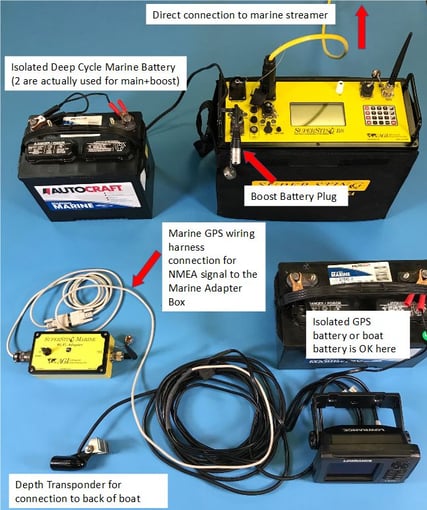
This shows a Lowrance GPS shipped in 2019. We now ship a Garmin GPS which has a smaller form factor and the same performance and connection method . Notice how the SuperSting battery and GPS battery are isolated from each other in the diagram above. This is a critical step to avoid a ground loop. You also cannot use the ships battery because other devices are connected and it and all are grounded to the water through one or more anodes. Do not connect any other device to the main and boost battery for the SuperSting. The GPS can use the ships battery without issue or it's own battery.
The SuperSting Marine WiFi Adapter must be fully charged with the provided charger. There is an internal battery in this device which can last 12 hours or more. It should be charged after each survey day overnight with a trickle charge setting (lower amp value). There is a charge-off-on switch which must be used for charging, storage or use. If you have time for overnight charge, set the charger to the lower value to create less heat and extend the longevity of the battery. The higher value should be used if you are not doing an overnight charge and in a hurry.
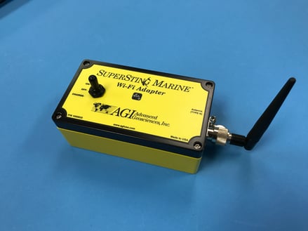
The SuperSting for marine surveys must use two batteries for Main and Boost due to the very low contact resistance and the related high amount of current transmitted. If allowed, it is much lighter and more reliable to use an isolated gas generator like the Honda 1000EU and the AC/DC power supplies. Do not connect these supplies to onboard AC available on larger ships as this is always grounded to the water as well.
A lithium ion based battery charger for the tablet will be needed if you plan a full day of surveys. Chargers of around 20000mAh will last more than a day of surveys and are widely available with little well under the cost of the tablet.
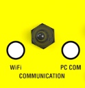
Deploy the streamer, connect all devices as shown and turn them on. The order is not important. Make sure the SuperSting communication switch is pointed towards WiFi and not PC COM.
Software Setup
1. Turn on your tablet that was included with your system and connect to internet WiFi to make sure you have the latest version of the App. Also check the SuperStingWiFi main menu for firmware .76E
2. Register the SuperSting™ Manager (SSM) App if not already done
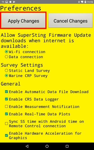
3. If you have purchased the Marine license—then at the Preferences screen, select the Marine CRP checkbox and press the "Apply Changes" button as seen below:
4. Setup a Wifi connection with your SuperSting™ WiFi. To do this, first, make sure your SuperSting™ is in Wifi mode by checking the switch on the console (see image below). In the SSM App's main screen, select the Wifi Settings button to open the Android Wifi settings. The WiFi SSID is SuperStingXXXX (XXXX = last 4 digits of your instrument serial number). You can find your password listed on the printed license sheet placed in the front pocket of your Instruction Manual folder
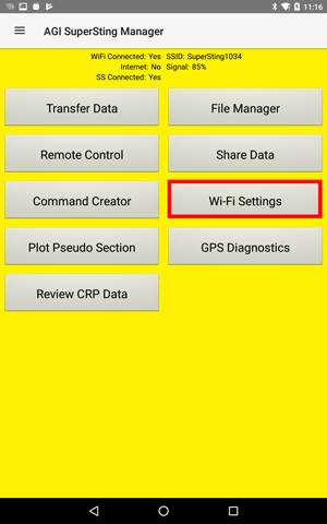
5. Go back to the SSM App main menu
6. Push the Remote Control button
7. On the Main Menu, press 1 to go to Automatic Mode
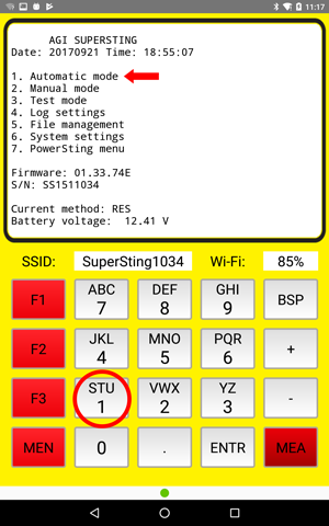
8. On the next screen, press 2 to create a new data file, then give your file a name (Max 8 characters)
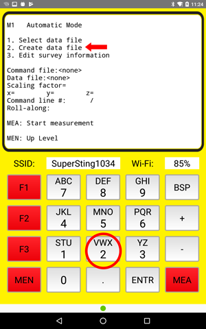
9. Pick your marine cmd file. As you can see below, we have provided one in the cmd directory called MarineDD
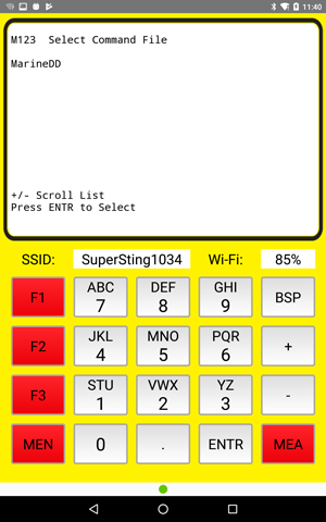
10. Continue through your setup by confirming/editing the information on the next few screens: Select Switch System Type = Dual-Mode Swift/Marine CRP
Cable Address Table in Menu 6/2/2 needs to be
Section Low High
1 1 11
With the App in Marine Mode, the measurement settings should have been changed to CRP type automatically (Cycles = 1, Measure Time = 800ms, etc.)
You are now done setting up the SuperSting™ for your marine survey and need to prep your system to start measuring:
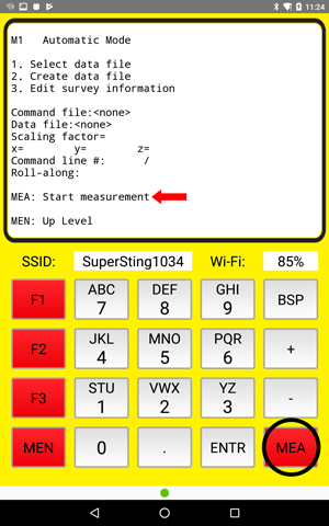
11. On the Automatic Mode screen, press the MEA button to select "Start measurement", as seen below. This will take you to the Marine Module tabs
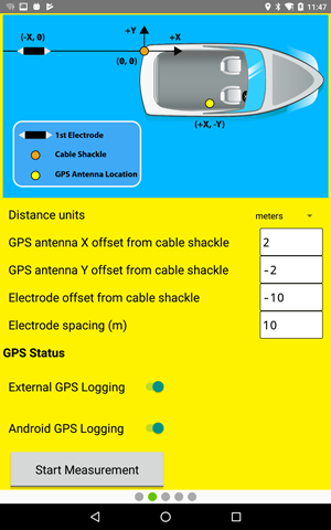
12. On the next screen, input offset coordinates for the GPS antenna and the first measuring electrode with respect to the cables anchor point on the boat. The first measuring electrode distance should include any chain or vinyl coated wire used to extend the streamer further off the back of the boat. A low anchor point at the water line should be used. Turn ON the external and Android device GPS logging. The External GPS logging will only become enabled if the SSM App detects a valid NMEA stream on the SuperStingXXXX WiFi network (with the $GPRMC NMEA sentence for lat/long; you may need to turn that ON in the external GPS unit). The next step shows you how to check if the NMEA stream is available and what NMEA sentences are enabled on the External GPS unit
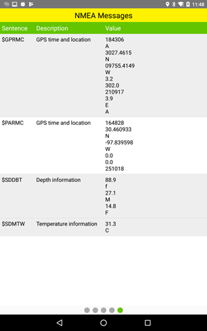
13. Swipe the screen to go to the NMEA tab (seen below) and make sure you are receiving the GPS strings for latitude, longitude, depth, and temperature. You may have to set up your external GPS unit to output the required NMEA strings ($GPRMC (for lat/long), $SDMTW (temperature) and $SDDBT (depth)
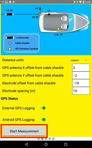
14. Swipe the screen to get back to the Offset Tab and push the "Start Measurement" button
Important Connections and Settings:
- Turn off any power saving features on the Android device to decrease interruptions in your work.
- Turn off any screen saver or screen time-out functions so that the screen doesn't time out during the survey.
- We recommend using an external power source for the tablet in addition to the tablet's internal power.
- The SuperSting™ AC/DC Power Supply is ideal for powering the tablet and SuperSting™ Marine
- Make sure the external GPS is powered by its own deep cycle battery and NOT the SuperSting battery
- Make sure nothing else is connected to the SuperSting™ batteries to avoid ground loops
- Make sure the deep cycle batteries and the SuperSting™ are electrically isolated (sitting on plastic, rubber or another other insulator) if you are operating with a metal boat hull. Ground loops that create noisy data can develop if not isolated properly.
